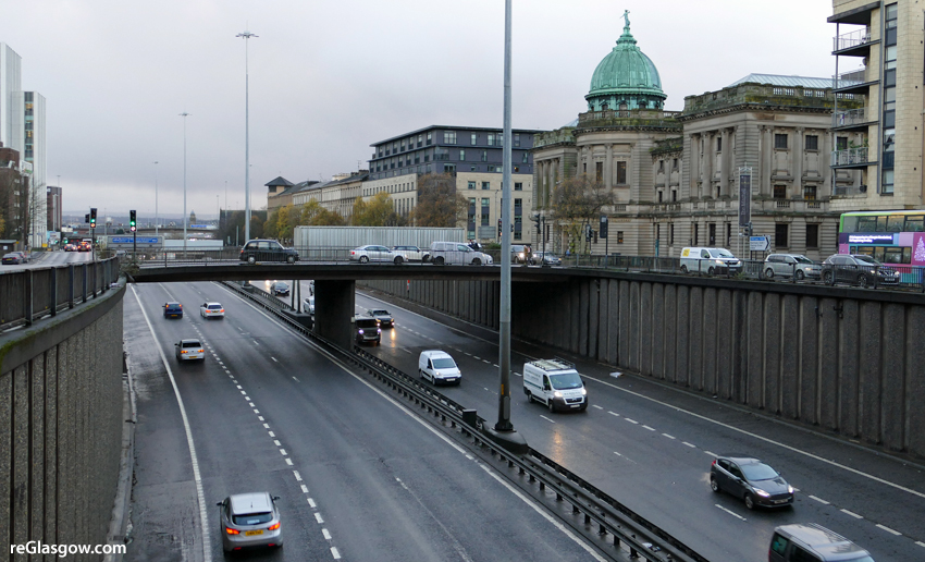
THE latest vision for Glasgow City Centre suggests down-grading the M8 as part of a massive shift away from car traffic, paving the way for transforming more streets.
Consultation on the Central District Regeneration Framework — which covers the city centre’s core — is expected to start on 6 December.
If adopted by Glasgow City Council, the framework will guide the physical, economic and social regeneration and development of the area.
Regarding mobility, it states: “Glasgow needs to shift away from its strong dependency on cars. Cars use space inefficiently, they pollute and make streets unattractive and unsafe.”
It highlights three great city assets:
— The rail and subway infrastructure, a legacy of Glasgow’s Victorian Heritage when the city had almost twice the number of inhabitants.
— Most streets are wide so there is enough space to introduce lanes for cyclists and widen footways.
— The upgraded M74/M73, described as the “ideal” loop around the city centre to “replace the M8 as a national thoroughfare”.
The document states: “The M8 can be downgraded to become part of a local city centre ring that accommodates displaced through-traffic from the city centre.
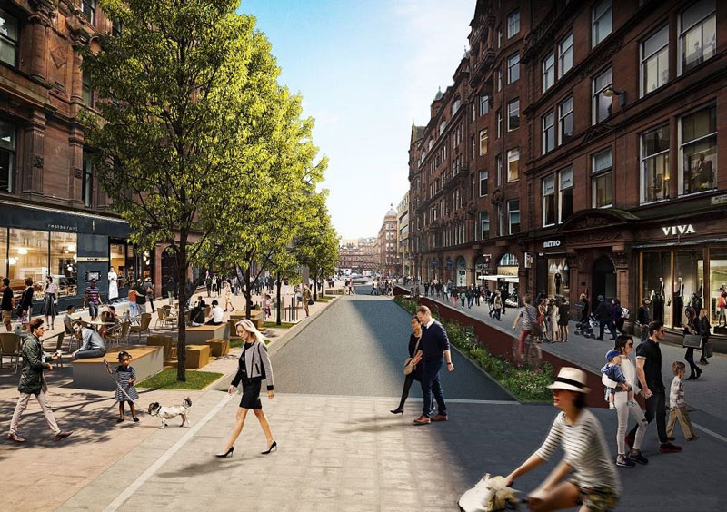
“Glasgow should use these three assets to change its ‘modal split’ to more sustainable modes of transport. By intelligently moving the car to the periphery of the city centre, and by creating a seamlessly integrated public transport and cycle network, the city will become more attractive, more liveable and it will attract new investments.
“With the proposed reduction of car traffic in the city centre (no more through traffic, less street parking, better public transport) street space becomes abundant.
“The proposal is to dedicate the freed-up space to specific users; creating streets with a particular functional profile, resembling a Tartan pattern: dedicated bus streets, cycle highways, pedestrian boulevards or just green calm neighbourhood streets.
The completed Clyde Gateway/East End Regeneration Route would also play a major role in restricting the city to local traffic only, as it would allow the down-grading of High Street.
Other highlights include:
— Hielanman’s Umbrella, the unattractive area of Argyle Street under Central Station — would be turned into a “light and attractive station lobby”.
— Central Station: Consideration to be given to complete pedestrianisation of Gordon Street (with taxis / buses providing drop off on Hope Street and Union Street).
— Reversing the one-way system around Central Station so Union Street is northbound and Hope Street southbound to allow better interchange between bus and train, avoiding the need to cross over streets.
How Bothwell Street could be enhanced
— Bothwell Street is seen as acting as a ‘High Street’ for the Central Business District so the quality of the streetscape environment requires significant enhancement.
–‘Designing for rain’: The framework explains: “Despite the climate and prevailing wind / rain, Glasgow has very few sheltered or covered 24/7 publicly accessible spaces. “This proposal seeks to increase comfort in key public spaces, by creating covered streets / squares / lanes so Glaswegians can enjoy being outside more often.” The effort would be focused on installing canopies in areas between key public transport facilities — such as Central Station, Queen Street Station and Buchanan Bus Station — including parts of Buchanan Street.
Blueprints are being drawn up for all nine of the centre’s distinct areas, the others being Blythswood, St Enoch, the Learning Quarter, Sauchiehall/Garnethill, Broomielaw, Townhead, Cowcaddens and Merchant City.