A BLUEPRINT for the next decade of development in the Blythswood section of Glasgow City Centre sets out various measures for lessening the impact of the M8 motorway, as well as opening up Blythswood Square as a park.
The draft district regeneration framework (DRF) is due to go out for public consultation.
The Blythswood area is focused on Blythswood Hill, running down towards the Clyde to the south and to Sauchiehall Street to the north. The M8 cuts through the area as it crosses the river via the Kingston Bridge before cutting around the west and northern flanks of the city centre.
The document states: “This District Regeneration Framework outlines a vision, projects and an action plan to refocus the Blythwsood district of Glasgow in the next ten years. This part of the city centre is undergoing a repositioning which, if successful, could be transformational to the city’s economic, cultural, social and civic health and future prosperity.
“The city centre’s relationship with the motorway is crucial and this DRF addresses how to mitigate the negative impact the M8 has on the adjacent urban environment. Any future plans would have to be developed in collaboration with key stakeholders, including Transport Scotland.
“The opportunity to retrace and reinforce lost or underwhelming arterial routes across the motorway to join up established and emerging ‘high street’ centres is important. As Finnieston / Argyle Street matures as a revitalised retail / leisure destination, super-charged by the Scottish Event Campus, there exists an opportunity to link and regenerate Sauchiehall Street and Argyle Street from the city to the West End.
“The City Deal Avenues investment on both streets, should act as the basis for a regeneration strategy that supports local businesses by maximising street-life and footfall and creating a far more attractive destination infused with culture and creativity.”
Addressing the impact of the motorway, the framework states: “Currently the M8 is designed like a traffic machine. It has a negative impact on the surrounding city. The ambition is to untangle the M8 knot and reduce the negative impact of the motorway ‘spaghetti’.
“The M8 currently has a lot of intersections with the local network. The proposal is to reduce the amount of intersections and make the slip roads that run parallel to the M8 more important as an interface between local network and motorway.”
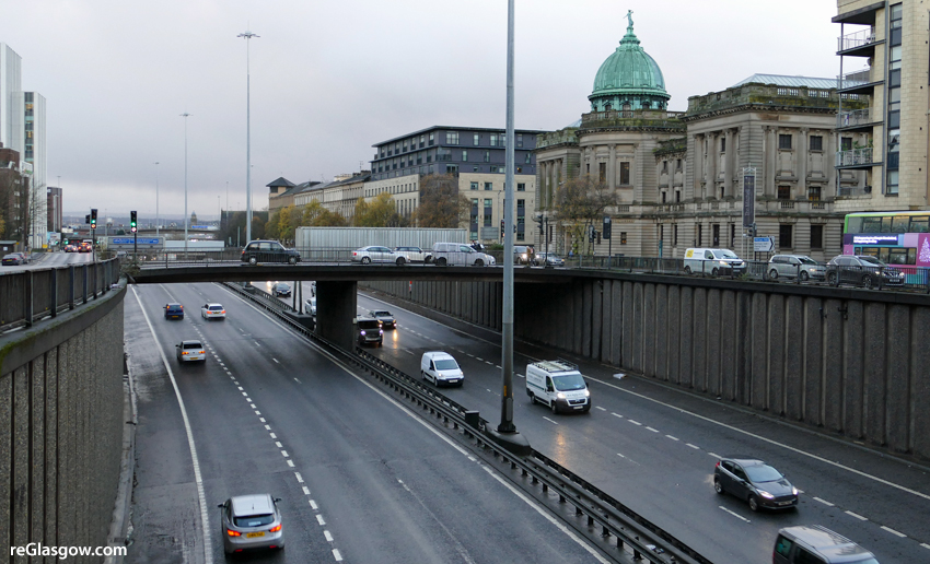
It suggests there is scope to increase the number of crossing points along the M8 for cyclists and pedestrians. The lack of connections has meant the western part of the district (Anderston) had declined.
“It is important to consider all possible ways in which the city fabric can be reconnected,” it insists, adding that the possibility of reconnecting William Street and Bothwell Street would be investigated. A new bridge could be integrated with noise barriers and should be “attractive, spacious and green”.
Connecting Kent Road with Elmbank Crescent is described as a strategic action that would ease access to the Charing Cross train station from the west and increase its usage.
The document continues: “To increase liveability of the city centre, it is desirable that sound barriers are installed in the stretch of the M8 that runs through the city centre. These barriers are also elements that add functionality and visual quality to the surrounding streets.
“Other measures should include sound absorbing asphalt and other mitigation measures to reduce the traffic noise, alongside seeking to reduce the congestion on the motorway network by modal shift to public transport and active travel.”
More options raised include a cap over the motorway at Charing Cross; wider bridges over the M8 with green, play spaces and walls to reduce the feeling of crossing a motorway; and building over the M8 — “This is one of the few spaces left over for mixed use development, city parking, green and play spaces.”
Other elements of the framework include:
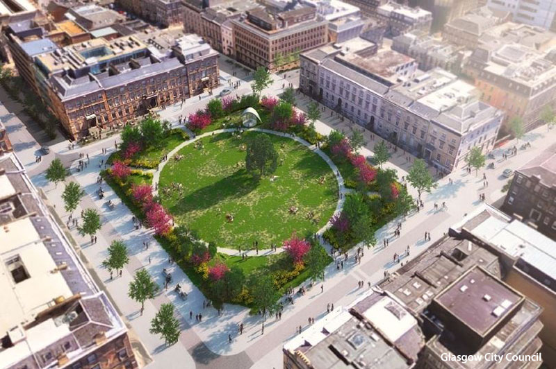
— Transforming Blythswood Square into a quality day-time urban square / public park.
— Creating an attractive all-year / all-weather urban playground on Blythswood Street, exploiting the steep slope and great views.
— West George Street be redefined as a key part of a pedestrian loop connecting George Square, Blythswood Square to a proposed River Park, Charing Cross Station and the West End.
— Major improvements to the St Vincent Street streetscape.
— Increased provision of public space by rejuvenating empty sites with ‘pocket’ public parks and playgrounds (especially in Anderston)
— Improving the appearance of residential ‘mega-block’ Blythwood Court “currently a badly integrated unattractive 70’s structure with lots of vacant spaces”.